
TREK DURATION
8 days
HIGHEST ALTITUDE
15,250 ft
TREK DISTANCE
36 kms
AGE LIMIT
10 to 68 years
Visit Alpine Lake in the Winter
One of the highlights of a Himalayan trek is witnessing an alpine lake. Unfortunately, snow accumulation makes most alpine lakes inaccessible in the winter.
Yet, on the Brahmatal trek in winter, you not only trek to an alpine lake but also get to camp near it. The Brahmatal trek is exceptional because of this.
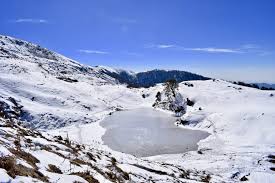
Standing next to Brahmatal frozen waters, you are at a height of roughly 12,000 feet. The views are breathtaking. The lake is in a crater; the water is crystal clear; there is a shrine beside it, and a lone tree stands on the far bank. Mt. Trishul and Mt. Nanda Ghunti, two of our nation’s most stunning mountains, are visible behind the ridge that surrounds the lake.
We camp just beyond the lake if the snow is manageable. The experience of camping in such a setting is in itself an experience.
While all the attention is on Brahmatal, let’s not forget Bekaltal, another lake we love. Lower down, Bekaltal is another breathtaking sight encircled by thick forests.
This trek includes one of our best-forested walks. If there is a layer of snow on top, it gets
even better. The forests are beautiful but not completely engulfed. Through the trees, you can see a long way away, giving you a sense of openness.
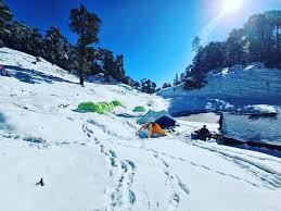
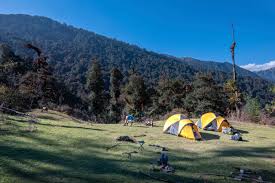
On this trek, each campsite is distinctive. Keep an eye out for our camp in Gujreni. It is a lovely hideout tucked away in a clearing. Also excellent are the campsites at Tilandi and Brahmatal.
The trekkers’ favourite is Tilandi. The sunset from Tilandi, especially on Mt. Trishul, is unforgettable. Trekkers love the open high ground of Tilandi as well. The views from Tilandi are so grand that trekkers want to spend more than a day there.
Brahmatal is a new trek. Nevertheless, it has rapidly grown in popularity. There’s a good reason for this: the trek has almost perfect conditions for a winter snow trek.
Make the trek in January, February, and March to avoid the crowds. The snow is deeper than in December, minus the crowd on the trail.
Brahmatal Trek Information
Quick Itinerary
DAY 1
Drive from Rishikesh to Lohajung
Drive distance: 260 km
Drive duration: 10-11 hr
Pick up point for The Valley Ridesassembly point Natraj Chowk, Rishikesh
Pick up Time: 6.30 am
Location of The Valley Ridescamp site: Lohajung
It is a 9–10-hour drive from Rishikesh. Transport will be available from The Valley Ridesassembly point at Natraj Chowk, Rishikesh.
DAY 2
Trek from Lohajung to Gujreni
Trek distance: 4.5 km
Trek Duration: 6 hours
Altitude gain: 7,550 ft to 9,180 ft
DAY 3
Trek from Gujreni to Tilandi
Trek distance: 2.9 km
Trek Duration: 4-5 hours
Altitude gain: 9,180 ft to 10,495 ft
DAY 4
Trek from Tilandi to Brahmatal via Brahmatal Top
Trek distance: 6 km
Trek Duration: 5-6 hours
Altitude loss: 10,495 ft to 10,190 ft via 12,250 ft
DAY 5
Trek from Brahmatal to Lohajung
Trek distance: 8.45 km
Trek Duration: 7-8 hours
Altitude loss: 10,190 ft to 7,550 ft
DAY 6
Drive from Lohajung to Rishikesh
Drive distance: 260 km
Drive duration: 10-11 hr
Drop off Time: 7 pm
You will reach Rishikesh by 6-7 pm
IMPORTANT NOTE
Documents required: It is mandatory for trekkers to carry a copy of their photo id any one (Driving licence, Aadhar Card, Voter id) along with the mandatory documents of the Medical Certificate, Disclaimer form & 2 passport size photographs.
Cloakroom facility for excess luggage: We have a cloakroom facility available at the basecamp for extra luggage. Every trekker is permitted to leave behind one piece of luggage at Rs 500 per luggage.
Detailed Itinerary
DAY 1 (Pick-up Day)
Reach Lohajung
Drive Duration: 10- 11 hours’ drive from Rishikesh
Drive Distance: 260 km
Altitude: 7,550 ft (2,316 m)
Lohajung is the base camp for the Brahmatal trek. A great way to reach here is from Rishikesh. The drive from Rishikesh to Lohajung is picturesque. You drive through Devprayag, Rudraprayag and Karnaprayag, the confluence of Alakananda with Bhagirathi, Madakini and Pindar rivers respectively. You drive along mountain roads, and through forests. You also get glimpses of the Garhwal mountains in the distance on a clear day.
Once you reach Lohajung, you find yourself face to face with the beautiful Nanda Ghunti peak. Lohajung, as the local’s story, is the place where Goddess Parvati had a war with the demon, Lohasur. Hence, the name translates to ‘War with Lohasur.’
DAY 2
Trek from Lohajung to Gujreni
Trek distance: 4.6 km
Trek Duration: 5 hours
Altitude gain: 7,600 ft to 9,180 ft
Moderate; gradually ascending through forests on well-defined trails
The trek begins from Lohajung central market (chowk). Move upwards from Bisht General Stores on the well-marked, human-made trail. Walk through the upper region of Lohajung and then through the forest trail with a few more houses. After a short trek, spot Mandoli village on your left. As you climb higher, on your left, you will be able to see the Kali Valley, where Kali and Pindar Rivers join. Follow the water pipes that supply water to Lohajung, as they lie along the trek trail. After some time, cross a small cluster of homes on the left. Here, you will find rhododendron trees, which make this part of the trail very beautiful from February to March.
At approx. 8,500 ft, you will find a 10-metre bridge which will help you cross the stream. After around two hours, you will reach Begum, where you can rest for some time. This place provides splendid views of Navali Bugyal and Bagdi Bugyal. After 10-15 minutes of walking from Begum, you will find another stream. From here, an hour’s walk will bring you
to the Gujreni stream.
During winters, camp at Gujreni.
“This campsite is surrounded by green oak, brown oak, and rhododendrons. It’s inside a clearing and comparatively warmer as the sun rises around 8 and stays till 5 am.
From here, the trail enters thick Oak forests and keeps climbing moderately. At sections where the mountainside is to your left and the valley to your right, catch the first views of Mt Trishul imposing itself on the horizon. An hour and a half through the forest climb you land at a flat with a small crater in the centre. At one end of the crater, the plateau is the valley of Deval. This place is called Khopdalia. It is a small dried lake. This is the campsite for Bekaltal which lies just above the campsite.
Bekaltal is a ten-minute trek up from Khopdalia. It lies surrounded by a thick cluster of Oak trees. The waters of Bekaltal are always brown. The brown water indicates a high amount of dissolved organic matter.
DAY 3
Gujreni to Tilandi
Trek Distance: 2.9 km
Trek Duration: 4-5 hours
Altitude gain: 9,180 ft to 10,495 ft
Today is a short day. The trail starts off the campsite in the south-west direction. Just a few metres into the climb, you come across a stream crossing. From here, the trail climbs steeply into the Oak and Rhododendron Forest. Notice that to your left is the ridge which opens up to the valley below. Immediately to your right below is Bekaltal.
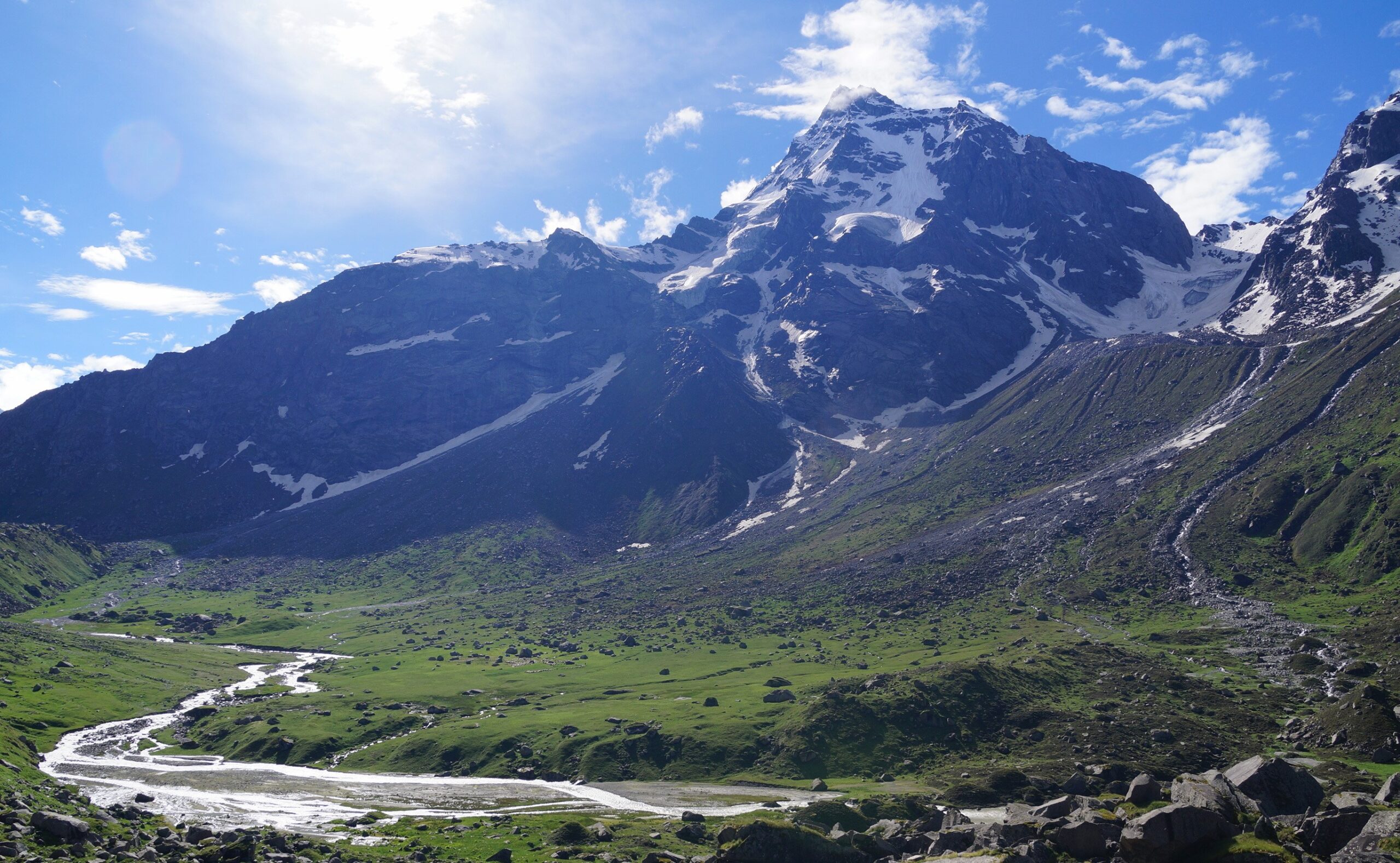
As you climb on further, half the trail is dominated by Rhododendron trees and somewhere midway the Oak trees take over. After about an hour of a trek in this lovely forest section, the tree line ends and you enter the meadows. Right in front of you is the spectacular panorama of Mt Trishul and Mt Nanda Ghunti with their associated ranges.
You are usually drawn to the edge of the meadows which is a ridge. This is your Tilandi campsite. Below you are the valley from Lohajung to Wan. Right opposite is the famous meadows of the Roopkund trail – Ali and Bedni Bugyals.
DAY 4
Tilandi to Brahmatal
Trek Distance: 5.5 km
Trek Duration: 7-8 hours
Altitude loss: 10,495 ft to 10,190 ft via 12,250 ft
Moderate. It is a long descent all the way to Lohajung.
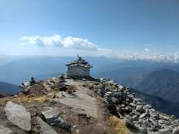
This day’s trail weaves along the ridge. You see the treeline sometimes below you, sometimes beside you as you gain and drop height. The trees are largely Rhododendron or Oak again. Overall, you gain height when you head to Jhandi Top, the highest point on the ridge. It’s another vantage point for clear views of the mountain panorama. You get spectacular views of Mt Trishul and Mt Nanda Ghunti ranges from here. You can map the entire Roopkund trail here, right from Wan to Roopkund. Spend at least 30 minutes at Jhandi Top to soak in the place. It usually gives you goosebumps to comprehend what you see in front.
As you walk along the ridge, the majestic mountains and sweeping valleys greet you. You see at least 7 to 8 layers of mountain ranges, one behind another. The sense of openness is unmatched to most trekking days anywhere.
From the Jhandi top, take the right trail, which is again a mountain ridge that gradually ascends to the Brahmatal Top at 12,250 ft, the highest point on this trek. The mountain views stay along with you as you walk on the ridge and reach the top. Spend some time and soak in the stunning views from the top.
The trail now gradually descends to Brahmatal. It’s a beautiful lake, the first view of which takes your breath away. There is a small Nag Devta Mandir next to it. If the lake is not frozen, you get a clear reflection of the night sky which is a stunning sight to witness.
The Brahmatal campsite at 12,250 ft is 500 meters away from the lake to the left on the edge of the slope. Do not miss to witness the sunset from the campsite.
DAY 5
Brahmatal to Lohajung
Trek distance: 8.45 km
Trek Duration: 7-8 hours
Altitude loss: 10,190 ft to 7,550 ft
Begin the descent to Lohajung right after breakfast. Take a trail that goes straight from the Brahmatal lake. Till Jhandi Top, the vegetation is sparse. The mountains play hide and seek with you as you gradually ascend to the Jhandi Top.
From the Jhandi top, take the trail that goes left. From here, you descend all the way to Lohajung. Initially you descend through an open space, with the mountain views now behind you.
About a kilometre of a descent, you enter the treeline again. This is all Oak trees now. Soon, you come across a clearing. This is called Khorurai as “Khoru” translates to oak. Take some rest here. It could also be a possible campsite if you wish to extend your trek for one more day.
It is well made all the way and crosses 2 streams in between.
Continue on the man-made trail from here. This trail connects these mountain villages down to Lohajung.
DAY 6 (Drive-back Day)
Lohajung to Rishikesh
Drive Duration: 10- 11 hours
Drive Distance: 260 km
How Difficult is the Brahmatal Trek?
Trek difficulty
Easy Moderate
Suitable for Fit Beginners
At The Cloudline, while rating a trek difficulty we consider a number of factors. These include altitude gained every day, length of trek every day, highest altitude, nature of the terrain, weather etc. Based on this we rate a trek as easy or difficult or somewhere in between.
Brahmatal trek climbs to 12,250 feet and we rate it as Easy-Moderate. This rating refers to marginally longer trekking days with a few steep climbs in between. So, the Brahmatal trek is a notch more difficult than the easy-moderate treks like Kedarkantha and Dayara Bugyal. But it has easy exits and there are no Difficult sections.
Coming to the details, you will cover a total of around 24 km in four days during which you will gain approximately 4,650 feet. On average, you will trek 7 km every day, which will include ascents and descents.
So, when talking about safety, there are two things you need to keep in mind — endurance and trekking in snow. Like other high-altitude treks, being physically fit is a must otherwise you will miss out on the beauty of this trek due to fatigue.
Best Time to do the Brahmatal Trek
Brahmatal Trek in Winter
- Day time: Between 8 °C and 10 °C | Night time: Will drop to temperatures between 0 °C and -8 °C.
- Presence of snow: You will find snow from the base camp towards the end of December. The entire landscape and valley will be in white.
- No. of warm layers required: 5 warm layers.
- When most treks in the Himalayas shut during peak winters – January and February, Brahmatal stays accessible. It remains open from December to February and then into spring.
- And that’s a treat because winter snow is heavenly on the Brahmatal trek. Although it makes the trek a notch more difficult. But the experience is still worth it.
- In winters, oak and rhododendron trees stoop under the weight of the snow lending a Narnia-like vibe to the trek. And this happens as soon as you set off from Lohajung.
- Apart from the snow, the sight of the frozen Bekaltal lake is mesmerising. Standing by it gives the impression of being frozen in time. But be careful about stepping on this frozen lake. Depending on the month, the ice may or may not be hard enough to support your weight.
- Another highlight of winters is camping on the snow at Tilandi with spectacular sunrises and sunsets. Unlike autumn, now the vibrant colours are reflected on the white, snowy landscape.
- And last year, trekkers filled their Instagram feeds with images of this campsite covered in snow.
- On the flip side, Brahmatal lake or top may not be accessible in the peak winters due to snow. But regardless of that fact, you will be able to witness the beauty of this trek from the ridge and the Tilandi campsite.
Brahmatal Trek in Autumn
- Day time: Between 10 °C and 15 °C
- Night time: Will drop to temperatures between 0 °C and -5 °C
- Presence of snow: You will not find any snow in the autumn season
- No. of warm layers required: 4 warm layers
- The flowers you witnessed in spring would have wilted and vanished in autumn, leaving a dark canopy of the rhododendron and oak trees. In this season, the trees start shedding leaves, offering a distinct crunch to your step as you walk over them.
- With that setting in place, look up at the mountain views. They’re the highlight in autumn, at their clearest post-monsoon when the air is free from haze.
- In this season, watch out for the ridge that Sandhya mentioned earlier in the trek guide. This ridge runs parallel to Ali Bugyal of the famed Roopkund trail. From here you can see the grand Trishul range rise over Asia’s largest meadow. It is a breathtaking experience.
- Further up the trek, as you reach Jhandi top, brilliant mountain views of Mt Chaukhamba, Mt Neelkanth, and Mt Hathi Ghoda open up under the blue autumn sky.
- There’s one more aspect of autumn that not many talks about, sunrises and sunsets. They are the most vibrant during autumn. Especially at the Tilandi campsite, simply because it is situated on the ridge.
- Words fall short, but watch out for the sunset when you reach Tilandi. It is a dramatic affair. The sun splashes vibrant crimson hues across the sky. And the next morning, wake up early to watch the golden sunrise on the other side.
- Lastly, autumn is also a great season if you like empty trails. But it’s not empty for the whole of autumn. For a quiet experience, aim for dates after Dusshera/Diwali vacation and before winter sets in. During this time the Brahmatal trail is at its emptiest.
Brahmatal Trek in Spring
- Day time: Between 15 °C and 18 °C | Night time: Will drop to temperatures between 0 °C and 5 °C.
- Great time to experience the last of the winter snow. The snow starts to recede from the lower campsites when spring sets. The upper reaches of Brahmatal are still under snow.
- No. of warm layers required: 3 warm layers.
- While Deoriatal-Chandrashila pops up in discussions when we talk about rhododendrons, not many know that Brahmatal too is a charming trek to do in spring. Its slopes are lined with rhododendrons (Buransh). And in spring, the slopes look fiery with Rhodos blooming dark pink and crimson. Imagine this in the backdrop of receding snow!
- But you won’t see these flowers throughout the trek. Although, you may start spotting lonesome trees in bloom from Lohajung itself!
- After that, as you begin your trek, watch out for the section between Bekaltal and
Tilandi. Here, just as you step out of Bekaltal, you enter a Rhodos Forest and the blooming flowers form a canopy over your head as you trek. - Finally, watch out for Rhodos towards the end of the trek, around Khorurai.
- For a magical experience, trek to Brahmatal in early spring (March). So that you get to trek on snow even as you see the flowers in bloom. During this time, you will find snow in sections upwards of Tilandi. As the season goes by, snow recedes to the higher altitude, around the Brahmatal lake which lies at 12,250 ft.
- By mid-April, most of the snow on the trail and around it has melted.
- Note: Although you can access Brahmatal in summers, it’s not a great season to experience the trek. During monsoons, the trek becomes inaccessible due to the rains. That brings us to the next season – autumn.
Packing List
Things you must take on the trek
MANDATORY DOCUMENTS
These are documents required for legal purposes by The Valley Ridesand the forest department. Without any of these, you will not be allowed to trek.
- Original and photocopy of government photo identity card. Anything such as a driver’s license, Aadhar Card, or passport will do. This is required by the forest department for your identification.
- Disclaimer certificate: There are two sections in this. The first part is a personal medical record. The second part is a legal requirement. Download the PDF, read carefully, fill in and sign it. This must be handed over to your Trek Leader during registration at the base camp. – Download Disclaimer Form
- Medical certificate: The medical certificate needs to be filled out by an MBBS doctor, without which the forest department will not issue permissions for your trek. It is also a requirement by The Valley Rides– Download medical certificate
Declaration Form – Download
Here is a list of everything you need for your trek.
Shoes and backpack
- Trekking shoes with ankle support)
- Backpack with rain cover
- Warm Layers and Clothes
- Warm layers –
1. 3 layers if you’re trekking in spring, summer and monsoon (1 woollen sweater, 1
fleece, 1 padded jacket)
2. 4 layers if you’re trekking in autumn (1 woollen sweater, 2 fleece, 1 padded jacket)
3. 5 layers if you’re trekking in winter (1 pair of thermals, 1 woollen sweater, 2 fleece, 1 padded jacket) - 3 Collared T-shirts (Wear one, carry two)
- 2 quick-dry trek pants (Wear one, carry one)
Accessories
- Sunglasses
- Sun cap with flaps
- Waterproof gloves
- Balaclava
- Socks (2 pairs of Dry fit + 1 pair of Woollen)
- Headlamp
- Trekking pole
- Rain jacket + pants/poncho
Toiletries
- Sunscreen
- Moisturiser
- Light towel
- Lip balm or Vaseline
- Toilet paper
- Toothbrush
- Toothpaste
- Reusable plastic covers (for used clothes)
- Water bottles
PERSONAL MEDICAL KIT
Carry these medicines with you, easily accessible at all times.
- Diamox: 1 Strip
- Dolo 650: 5 tablets
- Avomine: 4 tablets
- Combiflam: 5 tablets
- Digene: 4 tablets
- ORS: 6 packs
- Knee Brace: optional
You May Like
Dodital Darwa Pass Trek
Do Dham Yatra

Char Dham Yatra
Har Ki Dun Valley Trek

Subscribe newsletter $ get company news.
Ride the valley with us to explore the nature, waterfall and beauty. Valley rides Provide you a memorable experience to explore and feel the nature of Mountains.
Support
Contact Info
- The Conifer Inn Village Sour, Sankri , Teh. Mori District Uttarkashi, Uttarakhand
- © 2025 Ovatheme All Rights Reserved.


Reviews
There are no reviews yet.