

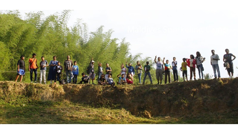
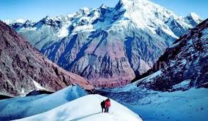
Winter Trek with the Vast Snow Expanse
Dayara has the vast snow expanse. It is so big and wide that sometimes you cannot see the end of the whiteness.
In winter, people want to see snow. Seeing it in such a wide canvas as Dayara is a one. What
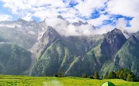
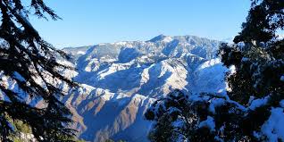
is more rare is the sight of Mt Bandarpoonch and Black peak towering almost 21,000 feet over Dayara. Seeing these mountains just popping out of the snow expanse of Dayara is the reason why anyone must do this trek.
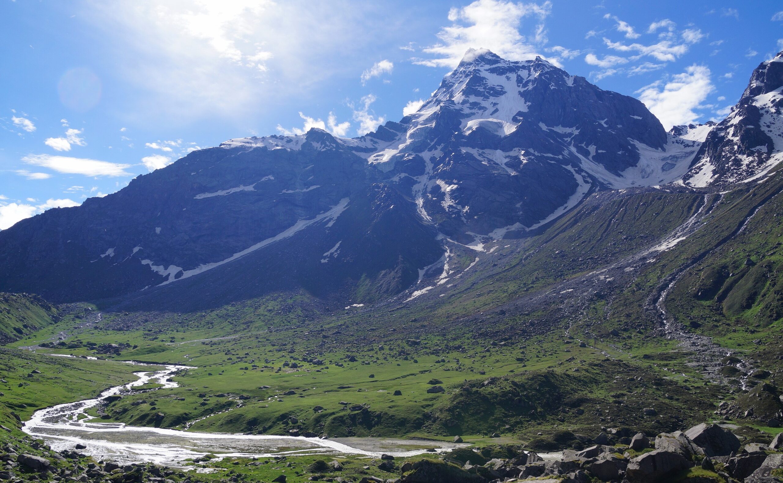
But it is not just these mountains. In a full sweep, panning from your left to right, in a wide panorama are some of the other great mountains of the Garhwal Himalayas — Mt Srikanth, Draupadi Ka Danda, and Mt Jaunli.
You get a big snow expanse only when you climb to very high altitudes. In Dayara, climbing to about 12,000 feet gets you to this vantage point. It is quite an adventure to get there. It needs some effort to climb through the forests, floors of which are lined by a carpet of snow.
The Dayara Bugyal trek in winter is a unique vast landscape. None of our winter treks has it.
Dayara Bugyal Trek Information
Learn about the Dayara Bugyal trek. It has detailed information about each day of the trek,
what to expect, and how you need to prepare for it. Many years of expertise have gone into
this content.
Short Itinerary
DAY 1
Drive from Dehradun to Raithal
Drive Distance: 185 km
Drive Duration: 9 hours
Pick up point: The Valley Rides assembly point at Gandhi Road Dehradun.
Pick up Time: 7.00 am
Location of The Valley Rides basecamp: Raithal
DAY 2
Trek from Raithal to Gui
Trek Distance: 4.5 km
Trek Duration: 5 hours
Altitude Gain: 7,142 ft to 9,630 ft
DAY 3
Trek from Gui to Chilapada
Trek Distance: 2.5 km
Trek Duration: 2-3 hours
Altitude Gain: 9,630 ft to 10,515 ft
DAY 4
Trek from Chilapada to Nayata via Dayara Top
Trek Distance: 9.5 km
Trek Duration: 6-7 hours
Altitude Gain and Loss: 10,515 ft to 9,186 ft via 11,830 ft
DAY 5
Trek from Nayata to Raithal
Trek Distance: 4 km
Trek Duration: 4-5 hours
Altitude Loss: 9,186 ft to 7,142 ft
DAY 6
Drive back from Raithal to Dehradun
Drive distance: 185 km
Drive Duration: 9 hours
Drop off point: Railway Station
Drop off Time: 6 pm
IMPORTANT POINTS
Documents required: It is mandatory for trekkers to carry a copy of their photo id along with the mandatory documents of the Medical Certificate and Disclaimer form. This is required for trek permissions. The medical certificate along with the disclaimer form will be part of the Safety Check-in done by the trek leader when you arrive at the base camp.
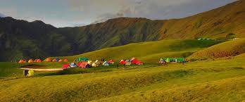
Stay facility: Your accommodation will be organised in Swiss tents at our Raithal Campus. After getting on the trail, you will be camping in twin-sharing Tents designed for high altitude expeditions by.
Cloakroom facility for excess luggage: We have a cloakroom facility available at the basecamp for extra luggage which is chargeable at Rs. 400/- per luggage.
Detailed Itinerary
DAY 1 (Pick-up Day)
Drive from Dehradun to Raithal
Drive Distance: 185 km
Drive Duration: 8 hours
Altitude: 7,142 ft
Highlights: Watch out for Tingling Point, from where you get to see the astounding views of almost all of Uttarakhand’s highest peaks, including Mt Nanda Devi.
Raithal, the base camp for the Dayara Bugyal trek, is around 9 hours away from Dehradun.
The drive takes you through lovely forest stretches as soon as you exit Dehradun. Within an hour, you pass through Mussoorie, one of the most popular hill stations of Uttarakhand.
Between Mussoorie and Uttarkashi, you come across a viewpoint, often called the Tingling Point, from where you get astounding views of almost all of the Garhwal Himalayas. Right from the mountains near Himachal (Swargarohini and adjoining peaks) to Mt Bandarpoonch to Mt Srikanth, the Gangotri Peaks, the Chaukhamba massif, all the way to Mt Nanda Devi, you get striking views. This is of course possible only on a very clear day.
The largest town on the route is Uttarkashi, from where you head to Bhatwari.
As you approach Raithal, you witness the brilliant colours of sunset over Mt Bandarpoonch, Mt Srikanth, Mt Jaunli and Draupadi ka Danda peaks.
Night stay at Raithal.
DAY 2
Trek from Raithal to Gui
Trek Distance: 4.5 km
Trek Duration: 5 hours
Altitude Gain: ⇗ 2,488 ft (7,142 ft to 9,630 ft)
Difficulty: Easy-moderate. Gradually ascending trail throughout.
Highlights: Lovely oak forests with leafy forest floors. Sunset by the lake at Gui.
At Raithal, you can see Mt. Srikanth and Gangotri 1, 2, and 3 in the distance along with the mountains mentioned above. These become more prominent as you gain altitude on the trail to Gui.
The forest where the Gui campsite is located is visible from Raithal.
The trail from Raithal to Gui is a gradually ascending one. The initial trail goes out of the Raithal village quickly and takes you through the village fields. Go along the well laid out trail and in an hour, you come to a flat grassy clearing which also has a hand pump. Take a small water break here and then proceed.
Post the water point, the trail becomes more wooded. You make your way into a forest that consists mainly of green and brown oaks (moru and kharsu) and rhododendron. This makes it a very rich forest. Unlike other places, you do not find pines here.
The forest opens up to a couple of small clearings before you reach Gui.
The campsite at Gui is located in a small clearing surrounded by forests. There is a small table close by. You will find village huts around – these are used by villagers in the summer. There is also a u-shaped forest department hut at some distance.
DAY 3
Trek from Gui to Chilapada
Trek Distance: 2.5 km
Trek Duration: 3 hours
Altitude Gain: ⇗ 885 ft (9,630 ft to 10,515 ft)
Difficulty: Easy. Meandering flat trail through the forest
Highlights: Beautiful oak forests with mountains peeking through the trees. First views of Mt
Bandarpoonch.
The day’s trek sees you carrying on along the trail the climbs out of Gui towards Dayara. As you climb up from Gui, you start seeing mountains on the other side, which were earlier hidden from view.
Today is a short day (3 km) with gradual ascends punctuated with flat sections.
Once you start from Gui, join the main trail and start climbing to Gui Thatch. This is a small meadow in the forest. On one side we have 5-6 Chania (shepherd) huts. Right in front of these huts is a compact pond. Just by the pond is a mound.
You also see the igloo-shaped structures of the Forest Department near the Chania huts. Beside the shepherd’s hut, you see Forest Department huts in the shape of igloos.
Gui Thatch has incredible views of the entire Gangotri range. These include Shrikanth, Gangotri I, II and III. Look straight, you see the Jaonli peak there. On your left, you can spot the top of Bandarpoonch.
The next half kilometre from Gui Thatch is a relaxed and easy walk. It goes through beautiful rhododendron. The terrain allows you to leisurely walk and soaks in the setting of a Himalayan Forest.
Spend some time connecting with nature. If you are trekking with The Valley Rides, your Trek Leader may facilitate the hug-a-tree experience here that helps you connect much more deeply with the forest.
You gradually start ascending once the relaxed forest walk ends. You cross a couple of streams which may be flowing, dried or frozen depending on the season.
Barely five minutes after crossing these streams, you see an umbrella-shaped rain shelter. This is the rest point. Chilapada is not far from here. Catch your breath, stretch your legs and pause for 10-15 minutes before proceeding further.
Chilapada is 20 minutes from the rain shelter. Five minutes into the trek from the rain shelter, notice a broken trail on your left. Leave the main trail and start trekking on this broken trail. This goes to Chilapada, a small opening between the meadows.
Look around, on one side you have the Chilapada Top with some Chania huts. Night stay in Camp.
DAY 4
Trek from Chilapada to Nayata via Dayara Top
Trek Distance: 9.5 km
Trek Duration: 6-7 hours
Altitude Gain and Loss: ⇗ 1,435 ft; ⇘ 2,764 ft (10,515 ft to 9,186 ft via 11,830 ft)
Difficulty: Moderate. Undulating walk across meadows followed by a final ascent.
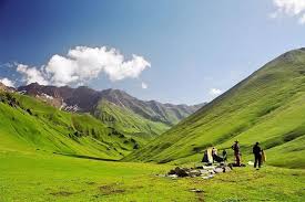
Highlights: The grand meadows of Dayara Bugyal, set against the backdrop of the Gangotri range of peaks and Mt Bandarpoonch.
Chilapada is pretty close to the start of Dayara Bugyal giving you almost the whole day to explore the massive meadows.
Climb through the forests and in half an hour the tree line ends and you find yourself at the edge of meadows. You do not see the full magnitude of the meadows yet.
Here you can spot the Chania huts in front. The trail goes right on the edge of the meadow. Look up to your right to see the magnificent view of Bandar Poonch and Kala Nag. All the summits which were with you from Raithal and Gui are now a lot bigger adorning the panorama behind.
Photo point: The early morning view of Dayara Bugyal is worth every effort put in to get there. Miles of undulating meadows stretch in every direction, with the rays of the sun catching them in many moods.
If early in the season (May-June), thousands of yellow, violet and white flowers sprout across the meadows – sometimes, there are so many that you have to deliberately skirt around them.
In winter, you see miles and miles of powdery snow on the undulating terrain.
Spend at least a couple of hours exploring the Dayara meadows before retracing your steps to the Chania huts. The trail to Nayata goes below the huts and immediately enters the forest. The wooded trail is well laid out again. About 45 minutes of descent brings you to Nayata.
DAY 5
Trek from Nayata to Raithal
Trek Duration: 4 km
Trek Duration: 4-5 hours
Altitude loss: ⇘ 2,044 ft (9,186 ft to 7,142 ft)
Difficulty: Easy. Short stretches of ascents and descents for 1.5 hours followed by a steeply descending trail
Highlights: Pleasurable descent through a lovely canopy of trees. Last views of Mt Bandarpoonch It takes about 4 hours to reach Raithal, so start your days trek by 9 am. From the Nayata campsite, continue on the main trail you came down from Dayara yesterday. The trail continues to descend under a heavy canopy of forest cover.
Fifteen minutes of descent brings you to the rain shelter from where you diverted to Barnala on the way up. Continue moving down on the main trail.
Continue further for an hour before coming to the grassy clearing with the water source. Take a break here before completing the final hours descent to Raithal. The arch of Raithal marks the end of the trek. The Valley Rides Campus is half a kilometre down the paved road. Continue till you reach the community campus. It brings an end to your enchanting Dayara Bugyal trek.
Night stay at Raithal Camp.
DAY 6
Drive from Raithal back to Dehradun
Drive Distance: 185 km
Drive Duration: 8 hours
Highlights: Crossing the Tehri Dam and Tingling Point.
Start from Raithal after breakfast. Enjoy the scenic drive back to Dehradun. You are expected to reach Dehradun at around 7.00 PM on this day.
How Difficult is the Dayara Bugyal Trek?
Easy-Moderate Trek
Suitable for Beginners
Dayara Bugyal is a perfect trek for beginners, it can even be considered as a pre-trek to get used to the rigours of high-altitude trekking. Almost like an appetizer. It does not have tricky sections, but a couple of sections on the trek can get challenging. Amongst the high-altitude treks on our list (treks that go over 11,000 feet), Dayara Bugyal poses the least risk.
This is why it’s a trek we recommend to many beginners, families and even those starting trekking late in their lives.
Best Time to do the Dayara Bugyal Trek
Dayara Bugyal is a trek that can be done around the year except during the monsoons. This means that the trek is open and great for almost 9 months in a year.
If we take out the monsoons, we get 4 distinct seasons to experience Dayara Bugyal – Winter, Spring, Summer and Autumn. Each season is different and lovely in its own way.
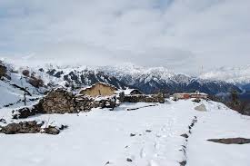
Dayara Bugyal in Winter
°C
Day time: Between 8 °C and 12 °C | Night time: Will drop to temperatures between -5 °C and -10 °C.
Presence of snow: You will find snow from the base camp towards the end of December. The entire landscape and valley will be in white.
No. of warm layers required: 4 warm layers.
In winter, people trek to Dayara Bugyal to experience snow. The landscape again changes colour when draped in the white snow. Soft, powdery snowflakes loosely hang from pine trees offering a tinge of Christmas-y feel. Perfect for snowball fights and an experience of snowfall if you’re lucky. However, snow raises the difficulty of the trek by a notch. So, prepare well if you are going in winter.
Dayara Bugyal in Spring
°C
Day time temperature: Between 13 °C and 17 °C | Night time temperature: Will drop to 0 °C.
Great time to experience the last of the winter snow. The snow starts to recede from the lower campsites when spring sets. The upper reaches of Dayara are still under snow.
No. of warm layers required: 2-3 warm layers.
Spring in Dayara starts by mid-March and goes on till the end of April. The snows start to melt in the upper reaches while the grass begins to turn green in the lower meadows. Tiny flowers make their heads out of the grass while rhododendrons bloom on the trees.
The upper reaches of the Dayara meadows are usually under snow until mid-April.
Spring is a great time to experience colour contrasts on the meadows. You see snow, greenery and the colour of flowers altogether.
Dayara Bugyal in Summer
°C
Day time temperature: Between 18 °C and 20 °C | Night time temperature: Will drop to 5 °C.
Most of the snow has melted, owing to warmer temperature.
No. of warm layers required: 2 warm layers.
Summers are warm on Dayara Bugyal trek. Picture bright green meadows getting toasted under hot sunlight.
There is also a distinct summer fragrance in the air especially as you trek under the shadows of oaks and maples.
The atmosphere also gets hazier as there is a lot of dust and pollen in the air at this time. So, you might not get as sharp views as you get in autumn. But you will see the snow-capped mountains in their grandeur on a clear day.
There’s another plus side to the summers on Dayara Bugyal trek. Without the challenges of cold temperature or snow, this trek is at its easiest in the summers. And so, we open the family batches of Dayara Bugyal trek during this time. It’s a great time to introduce children to the Himalayas.
Dayara Bugyal in Autumn
°C
Day time temperature: Between 12 °C and 15 °C | Night time temperature: Will drop to 2 °C.
There is no snow on the trek in the autumn season. The lush greenery on the trail starts to turn golden.
No. of warm layers required: 2 warm layers.
In autumn, the skies are at their clearest. That’s when you witness the sharp mountain views. Imagine the majestic Gangotri range, Bandarpoonch popping up from the golden meadows under brilliant blue skies. Sounds picturesque, doesn’t it?
And if you wish to capture these ranges through your camera lens, autumn is the perfect time to do so.
Other than the brilliant mountain views, Dayara Bugyal in autumn is a riot of colours. You will witness maple leaves turning fiery red. This is a signature sight in the Himalayas, and against the backdrop of meadows turning golden, well, it is a sight to behold.
Witness these as you trek, inhaling the crisp, pine-scented autumn air.
What to Pack on the Trek
Things you must take on the trek
MANDATORY DOCUMENTS
These are documents required for legal purposes by The Valley Rides and the forest department. Without any of these, you will not be allowed to trek.
- Original and photocopy of government photo identity card. Anything such as a driver’s license, Aadhar Card, or passport will do. This is required by the forest department for your identification.
- Disclaimer certificate: There are two sections in this. The first part is a personal medical record. The second part is a legal requirement. Download the PDF, read carefully, fill in and sign it. This must be handed over to your Trek Leader during registration at the base camp. – Download Disclaimer Form
- Medical certificate: The medical certificate needs to be filled out by an MBBS doctor, without which the forest department will not issue permissions for your trek. It is also a requirement by The Valley Rides – Download medical certificate
Declaration Form – Download
Here is a list of everything you need for your trek.
Shoes and backpack
- Trekking shoes with ankle support)
- Backpack with rain cover
- Warm Layers and Clothes
- Warm layers –
1. 3 layers if you’re trekking in spring, summer and monsoon (1 woollen sweater, 1
fleece, 1 padded jacket)
2. 4 layers if you’re trekking in autumn (1 woollen sweater, 2 fleece, 1 padded jacket)
3. 5 layers if you’re trekking in winter (1 pair of thermals, 1 woollen sweater, 2 fleece, 1 padded jacket) - 3 Collared T-shirts (Wear one, carry two)
- 2 quick-dry trek pants (Wear one, carry one)
Accessories
- Sunglasses
- Sun cap with flaps
- Waterproof gloves
- Balaclava
- Socks (2 pairs of Dry fit + 1 pair of Woollen)
- Headlamp
- Trekking pole
- Rain jacket + pants/poncho
Toiletries
- Sunscreen
- Moisturiser
- Light towel
- Lip balm or Vaseline
- Toilet paper
- Toothbrush
- Toothpaste
- Reusable plastic covers (for used clothes)
- Water bottles
PERSONAL MEDICAL KIT
Carry these medicines with you, easily accessible at all times.
- Diamox: 1 Strip
- Dolo 650: 5 tablets
- Avomine: 4 tablets
- Combiflam: 5 tablets
- Digene: 4 tablets
- ORS: 6 packs
- Knee Brace: optional
Inclusions & Exclusions
What is included in the tour
- Transportation to & fro from Dehradun to Raithal Base Camp.
- 2 nights camp/hotel at Raithal.
- 3 nights tented accommodation during the trek
- Trek equipment: Sleeping bags, Mattresses, Crampons, Gaiters, micro spikes, All kind of Utensils, Stools/chairs etc.
- Tents: Trekkers tent (twin/triple sharing), Kitchen & Dining tent, Toilet tent
- Entry Permit Fee, Guide Fee & Driver charges
- Standard vegetarian food for breakfast, lunch, snacks, and dinner during trek days
- 1 Mountaineering qualified & professional trek Leader
- Local Guide 1:6 ratio
- Chef & support staff
- Porters for carrying common equipment’s (like rations/tents/utensils/groceries)
- The facility of keeping extra luggage at our Raithal base camp, when leaving for the trek
- Personal accident insurance
- Insurance, transportations, salary of guide & porter
- Basic First aid Kit
- All government, local taxes and service charges
- The Valley Rides Fee
- Personalized Dri-Fit T-Shirt
What is NOT included in the tour
- The cost to reach Dehradun and back to your destination.
- Airport Pick up and Drop Off
- Personal trekking gear
- Tips for guide, chef, porter, etc (calculated per person)
- Excess baggage/porter charges
- Local sightseeing and entrance fee, camera fee, etc
- Mineral water or any type of soft drinks
- Hot water for shower, etc, during the trek
- Extra meals apart from inclusions
- Food during travel days
- Lunch and dinner while travelling from/to Dehradun
- Any other expenses incurred apart from inclusions
- All personal, medical, evacuation and emergency expenses like extra day stay or vehicle charges due to delays, landslides, evacuation.
Nag Tibba Weekend Trek
Do Dham Yatra
Char Dham Yatra
Bali Pass Trek
Har Ki Dun Valley Trek


Reviews
There are no reviews yet.