
TREK DIFFICULTY
Easy-Moderate
TREK DURATION
7 days
TREK DISTANCE
15 kms
AGE LIMIT
10 to 70 years
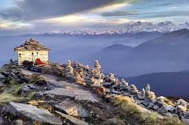
The winter trek with the mountain views
Seeing great mountain views on a winter trek is awesome. You have to get to a highest point to catch such a view. In winter, most such points are rare, and even if available, they are usually buried under deep snow.
Which is why at The Valley Rides we treasure the Deoriatal Chandrashila trek so much.
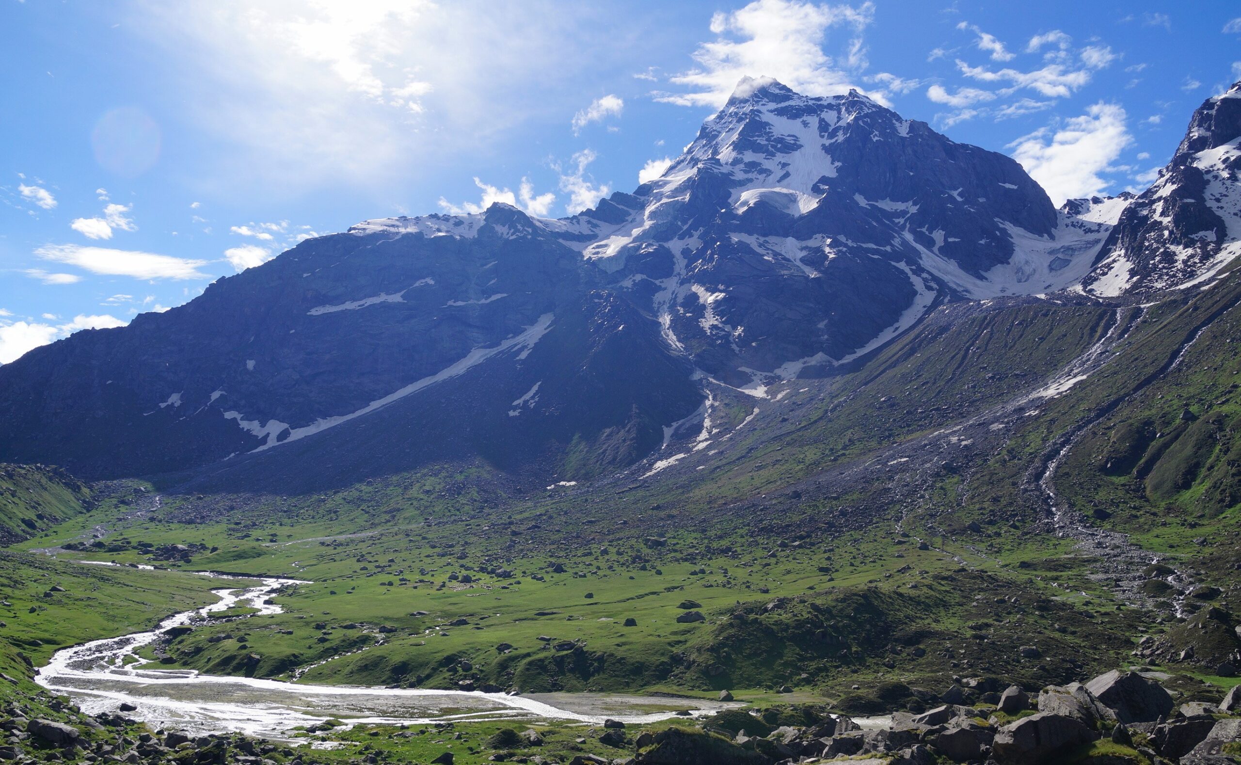
The Chandrashila summit is a vantage point that stands unparalleled among our treks. From the top of the summit, you see perhaps the greatest mountain views of Indian Himalayas.
It is like a grand feast — there is so much to take in that you cannot take all of it in. It is an experience many trekkers cannot forget.
What do you see? From your left are the Gangotri range of peaks, Mt Thalaysagar, the Kedarnath and the Kedar dome. Mandani Parbat and Janukut. The imposing Chaukhamba right in front. Most of them are over 6800 meters tall.
On your right are the Gauri Parbat, Hathi Parbat and Dunagiri. And then right ahead standing against the skyline is India’s tallest mountain, Mt Nanda Devi. Trekkers find it hard to believe that they are actually seeing Mt Nanda Devi.
If that was not enough, to Mt Nanda Devi’s right, etched against the skyline are Mt Nanda Ghunti and Mt Trishul. Two of the most beautiful mountain summits in our country.
It is not just the grand views. In winter, the trek in itself is special. The trail snaking through soft snow under the canopy of oak and rhododendron trees is almost dream-like. The Deoriatal lake is surrounded by snow, but looming over the lake is Mt Chaukhamba.
For us, just to catch the sight of Mt Chaukhamba from the shores of the Deoriatal is worth doing the entire trek.
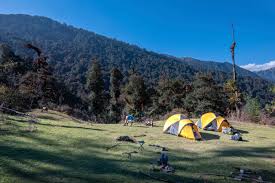
Besides Deoriatal, camping on snow at the campsite of Pilonji is a delight. The dense forests leading to the campsite is something that we don’t get on other treks. And everything changes with the canopy of white everywhere.
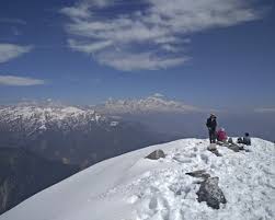
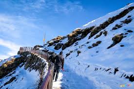
Having said all that, the biggest thrill of the trek has to be the climb from Chopta to the Chandrashila summit. In winter, with snow all around, climbing to the summit is an adventure that people do not forget in a lifetime.
There are only a handful of winter treks in our country. Deoriatal Chandrashila would be one of the better ones in our list. Do not miss out on this opportunity.
Deoriatal Chopta Chandrashila Trek Information
Use this section to learn about the Deoriatal Chopta Chandrashila trek. It has in-depth information about each day of the trek, what to expect, and how you need to prepare for it. Trekkers find that extremely useful.
Quick Itinerary
DAY 1
Drive from Rishikesh to Pilonji Base Camp
Drive Distance: 190 km
Drive Duration: 7-8 hours
Pick up point for I Pick up Time: 7.00 am
Location of The Valley Rides basecamp: Pilonji
The process of your registration, health screening, and document verification starts at 5 pm.
DAY 2
Trek from Pilonji to Deoriatal
Trek Distance: 3.60 km
Trek Duration: 3.5 hours
Altitude Gain: 6,260 ft to 7810 ft
DAY 3
Trek from Deoriatal to Pilonji
Trek Distance: 3.60 km
Trek Duration: 3 hours
Altitude Loss: 7810 ft to 6260 ft.
DAY 4
Drive from Pilonji to Chopta via Baniya Kund, Duggal Bitta.
Distance: 30 km
Drive Duration: 2 hours
Altitude Gain: 6260 ft to 8,888 ft
DAY 5
Acclimatization cum visit to sanctuary area.
DAY 6
Trek from Chopta to Chandrashila via Tungnath and back to Chopta
Trek Distance: 10 km
Trek Duration: 7-8 hours
Altitude Gain: 8,888 ft to 12,083 ft.
DAY 7
Drive from Chopta to Rishikesh
Drive Distance: 190 kms
Drive Duration: 7-8 hours
Drop off point for The Valley Rides Camp at Natraj Chowk. Drop off Time: 7 pm
Detailed Itinerary
DAY 1 (Pick-up Day)
Drive from Rishikesh to Pilonji
Drive Duration: 7-8 hours’ drive
Drive Distance: 190 km
Altitude: 6,560 ft
The journey is picturesque, as you pass through Devprayag, the confluence of rivers Alaknanda and Bhagirathi forms the river, Ganga. The entire journey traverses the mountainside, with the river flowing. Pilonji is a small village that you can explore. You can spend time at the campsite and to getting to know more about your team members or the story of how the campsite was built.
Pilonji, the base camp of the Deoriatal-Chopta Chandrashila trek, is a 7-hour drive from Rishikesh. The journey is picturesque, as you pass through Devaprayag, the confluence of rivers Alakananda and Bhagirathi to form the river Ganga. The entire journey traverses the mountainside, with the river flowing below you.
Pilonji is a small village with around 80 houses. If you reach Pilonji when the sun is still out, go to the village and walk around. The fields are so prettily laid out that they almost beckon to you. There is a small school amidst the fields. The views around the village are gorgeous. This is also where you’ll get your first glimpse of the of Chaukhamba.
You arrive at our The Valley Rides Basecamp of Pilonji.
DAY 2
Trek from Pilonji to Deoriatal
Trek Distance: 3.60km
Trek Duration: 2.5-3 hours
Altitude Gain: 6,260 ft to 7810 ft
Difficulty: Easy. The day starts from the village by climbing a few stairs, followed by a gradual climb on a well-defined Forest trail. A short walk on even terrain after 2-3 hours of trek takes you to the campsite.
Take in the pretty view of vast farmlands as you start your ascent from Pilonji. Watch out for the first sights of rhododendron trees. Do not miss the sunset at Deoriatal with the mighty Chaukhambha massif looming in the background.
The adventure starts at Pilonji. This is a well-defined Forest trail and is quite steep. After approximately 2.5 to 3 hours, you will reach to Deoriatal.
This spot is ideally located to relax and feast your eyes with a grand view of the mountains and the Ukhimat side of the valley. Turn back and witness the magnificent sight of Mt Chaukhamba from here.
From here, take the trail that goes by a beautiful rhododendron and maple forest. After a steady hike of ten minutes, you will reach the second viewpoint.
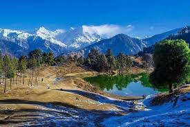
After a steep hill trek, your surroundings open up to a grand view of Deoriatal, with Mt. Chaukhambha massif looming in the background.
The lake is also called Devariya Tal because it’s believed that devis (Goddesses) once came to the lake to take a dip.
Photo Point: There’s a watchtower close to the lake that gives you grand views of the surrounding mountains.
Camping beside Deoriatal is not allowed anymore. So you will need to camp ahead where camping is allowed by the forest department. About 400 metres of ascent through a forest section lead you to the campsite space. The beauty of the view generally intensifies in the morning, when the clouds have cleared to offer unreal views of the hills.
Note: Do not miss the sunset from Deoriatal. The alpen glow of Mt Chaukhamba and the reflections of it over the lake is a beautiful sight to behold.
DAY 3
Trek from Deoriatal to Pilonji
Trek Distance: 3.60 km
Trek Duration: 2-3 hours
Altitude Loss: 7810 ft to 6260 ft
Difficulty: Easy. Gradual decent followed by 2-3 hours of steep descent to reach Pilonji camp.
Enjoy the trail through the thick forest cover till you reach Pilonji, your campsite for the day. This is a quiet section of the forest with an abundance of birds.
Walk from the campsite towards Pilonji in the south-west direction. A lovely forest trail awaits you. Full of rhododendron and maple trees, the trail is a picturesque one. Now and then, the Kedar Dome and Chaukhamba peaks peek at you through the trees on your left.
Take the ascending trail ahead of you as you get much better views from both sides of the valley. Towards your left, you can see the mountain ridge, from where a trail to Madhmaheshwar and Nandikund trek passes.
In March and April, the trail is blazing with red and pink flowers of rhododendron. The ridge has a small flat ground with unobstructed views from all sides. You can see the Mt Chaukhamba, Kedarnath and other snow-clad peaks. The forest continues to thicken throughout the trek. If you thought the forests until now were dense, you haven’t seen the start of it.
From here, proceed and take the trail that descends rapidly and connects with the forest ridge below. The flora of the region is stupendous. Also, keep an eye out for wild animals such as foxes and leopards.
Keep walking on a leisurely downhill trail inside a generous cover of the forest, which will give you respite from the late morning sun. This is a quiet section of the forest with an abundance of birds. The Himalayan woodpecker and Verditer Flycatcher can easily be spotted here.
DAY 4
Drive from Pilonji to Chopta via Baniya Kund
Drive Duration: 2 hours
Drive Distance: 30.4 km
Altitude Gain: 6260 ft to 8,888 ft
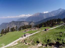
Start off from the Pilonji base camp. From here we will go to Chopta via Ukhimath. Ukhimath is a small town and famous for the Kedarnath & Madhmaheshwar Doli for the winter season. You can visit to temple here and darshan of Shri Kedarnath ji as well as Shri Madmaheshwar. After darshan we will be going to Chopta camp. Night stay at Chopta camp.
DAY 5
Acclimatization day.
Today we will have acclimatization and we will have short walk towards Mandal Road. While walking through the trails bird watching could be fulfilling.
DAY 6
Trek from Chopta to Chandrashila Peak via Tungnath and back to Chopta camp site.
Trek Distance: 7.5 km
Trek Duration: 5-6 hours
Altitude Gain: 8,520 ft to 12,083 ft
Difficulty: Moderate. Gradual ascent to Tungnath followed by a steep climb to Chandrashila for about an hour. The descent on the same path takes around an hour and a half to reach back to Chopta.
The big day of the summit to Chandrashila. Look out for Monals nesting in the trees or on the ground. The sunrise and the sunset view from Chandrashila are the best you will get to see in all of the Himalayas.
The trek up to Tungnath temple is approximately 3.5 km. It ascends sharply via a series of 11 scissor bends. The walk is pleasant but is a very steep climb. After you reach the 10th scissor bend, look for a flag and a small open temple towards your right side.
You can now see Chandrashila peak and the Tungnath temple complex at the base of the peak. The views from here onwards are incredible. A connecting peak leading to Chandrashila, known as Ravanshila, is visible to your right. Tungnath temple is only half a kilometre away from here.
Towards your left, overlooking the valley is a section of Birch trees (Bhojpatra). This is a haven for birds like Monal and Griffin vulture. Take the 11th and last bend to reach the famous and holy Tungnath temple. The temple is closed in winter and you will find snow here from late December until around April.
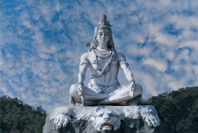
Local Story: Tungnath temple is the third of the Panch Kedars. These are 5 temples believed to have been built by the Pandavas to atone for the sins of killing their kin and Brahmins in the Kurukshetra war in the Mahabharata. Lord Shiva, whose forgiveness they sought, disguised himself as a bull. Parts of this bull appeared in 5 different places, each of these identified as a Panch Kedar. Tungnath is where his hands and chest are said to have appeared. This place has the distinction of being the only temple in the world to be located at such a high altitude (12,083 ft).
Chandrashila peak is 1.5 km above the temple complex. The route to Chandrashila peak is from behind the temple complex. Pass by the local dormitories and take the trail that winds from the right side of the base of Chandrashila peak. A trail goes by from here and takes a series of scissor bends.
During winter, expect this trail to be completely buried in snow. Those planning to do a winter trek, we provide crampons/micro spikes to everyone. The climb from Tungnath to Chandrashila is a 600 ft ascent and is a very steep climb.
After you negotiate a series of switchbacks, you will reach the upper base of Chandrashila Peak. From here, the summit of Chandrashila is visible. The climb up to the summit takes 1 hour.
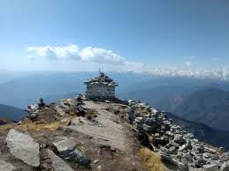
Once at the top of the peak, you get a 360-degree view of the mountains of Garhwal and Kumaon. Walk past a temple and see some great mountains of Uttarakhand, like Nanda Devi, Trishul, Nanda Ghunti, Kamet, Dunagiri, Chaukhamba, Kedar dome, Thalaysagar, Gangotri ranges, Janukut and more.
Photo Point: This spot is the best you will get to see in all of the Himalayas. At Chandrashila, you find another temple dedicated to Lord Shiva. This is believed to have been built by Rama to atone for the sin of killing Ravana. This temple is open from April to October. The deity is moved to Makkumath in winter.
The trek back to Chopta camp site is via the same route taken to reach here. It takes around 45 minutes to reach Tungnath and another hour and a half to reach Chopta from Tungnath.
DAY 7
Drive from Chopta to Rishikesh
Driving Distance: 190 km
Drive Duration: 7-8 hours |
Board your cabs from here for a drive back to Rishikesh. You will reach Rishikesh between
6.00 and 7.00 pm.
How Difficult is the Deoriatal Chandrashila Trek?
Easy-Moderate Trek
At The Valley Rides, while rating a trek difficulty we consider several factors. These include, altitude gained every day, length of a trek every day, highest altitude, nature of the terrain, weather etc. Based on this we rate a trek as easy or difficult or somewhere in between.
The Deoriatal Chopta Chandrashila Trek is an easy-moderate one. Frankly, out of all our high-altitude treks, Deoriatal Chopta Chandrashila is the safest one. It gains altitude slowly so your body has enough time to acclimatize. Nevertheless, it is a high-altitude trek that climbs up to 12,083 ft. At The Valley Rides, we don’t let our guard down at high altitudes, no matter what the altitude is.
While we do our bit to ensure a trekker’s life is safe, we also expect any trekker who is enrolling with us to know what could go wrong, and if it does, how to tackle it. To have a safe trek here is some information that you must know if you have registered for this trek. At The Valley Rides, we believe that as long as you are well-informed and well-prepared, you can survive easily at high altitudes.
Best Time to do the Deoriatal Chandrashila Trek
- January
- February
- March
- April
- May
- June
- September
- October
- November
- December
Even though Chopta Chandrashila or Deoriatal Chandrashila is a high-altitude trek. The trek is accessible for 10 months of the year except from July and August.
If we take out the monsoons, we get 4 distinct seasons to experience Deoriatal Chandrashila – Winter, Spring, Summer, and Autumn. Each season is different and lovely in its way.
Deoriatal Chandrashila in Winter
°C
Day time: Between 8 °C and 14 °C | Night time: Will drop to temperatures between -6 °C and -10 °C.
Presence of snow: You will find snow from the base camp towards January. The entire landscape and valley will be in white from December to the end of February.
No. of warm layers required: 5 warm layers In winter, people trek to Deoriatal Chopta Chandrashila to experience snow and the mighty views from the trek. So, prepare well if you are going in winter.
Deoriatal Chandrashila in Spring
°C
Day time temperature: Between 13 °C and 17 °C | Night time temperature: Will drop to zero
Great time to experience the last of the winter snow. The snow starts to recede from the lower campsites when spring sets. The upper reaches of Chandrashila and Tungnath are still under snow.
No. of warm layers required: 3-4 warm layers
Spring in Deoriatal Chandrashila starts in early March and goes on till the end of April. The snows start to melt in the upper reaches while the grass begins to turn green in the lower meadows. The upper reaches of the trek are usually under snow until mid-April.
Spring is a great time to experience colour contrasts on the meadows. You see snow, greenery and the colour of flowers altogether.
Deoriatal Chopta Chandrashila trek in Summer
°C
Day time temperature: Between 18 °C and 24 °C | Night time temperature: Will drop around 3-8 °C
No. of warm layers required: 2 warm layers Summers bring out a green colour palette on this trek, one that you might not witness in any other
season.
The forests and meadows look bright and sunny during May-June. Early in June, slopes may receive light summer showers and the flora turns lush.
The trek is at its easiest and is a great getaway from the summer heat of the plains. It also makes for the perfect time to introduce children to the Himalayas during the summer vacations.
Deoriatal Chopta Chandrashila trek in Autumn
°C
Day time temperature: Between 10 °C and 15 °C | Night time temperature: Will drop to zero.
No. of warm layers required: 3-4 warm layers.
The next best time to do the trek would be in the post-monsoon months of September, October and November. Post monsoon, the sky is washed clean of all the haze.
And it’s a perfect time for the Deoriatal Chopta Chandrashila trek which is known for the stunning views of the Garhwal Himalayas. It is in autumn that you get the clearest views of these mountains.
MANDATORY DOCUMENTS
These are documents required for legal purposes by The Valley Rides and the forest department. Without any of these, you will not be allowed to trek.
- Original and photocopy of government photo identity card. Anything such as a driver’s license, Aadhar Card, or passport will do. This is required by the forest department for your identification.
- Disclaimer certificate: There are two sections in this. The first part is a personal medical record. The second part is a legal requirement. Download the PDF, read carefully, fill in and sign it. This must be handed over to your Trek Leader during registration at the base camp. – Download Disclaimer Form
- Medical certificate: The medical certificate needs to be filled out by an MBBS doctor, without which the forest department will not issue permissions for your trek. It is also a requirement by The Valley Rides – Download medical certificate
Declaration Form – Download
Here is a list of everything you need for your trek.
Shoes and backpack
- Trekking shoes with ankle support)
- Backpack with rain cover
- Warm Layers and Clothes
- Warm layers –
1. 3 layers if you’re trekking in spring, summer and monsoon (1 woollen sweater, 1
fleece, 1 padded jacket)
2. 4 layers if you’re trekking in autumn (1 woollen sweater, 2 fleece, 1 padded jacket)
3. 5 layers if you’re trekking in winter (1 pair of thermals, 1 woollen sweater, 2 fleece, 1 padded jacket) - 3 Collared T-shirts (Wear one, carry two)
- 2 quick-dry trek pants (Wear one, carry one)
Accessories
- Sunglasses
- Sun cap with flaps
- Waterproof gloves
- Balaclava
- Socks (2 pairs of Dry fit + 1 pair of Woollen)
- Headlamp
- Trekking pole
- Rain jacket + pants/poncho
Toiletries
- Sunscreen
- Moisturiser
- Light towel
- Lip balm or Vaseline
- Toilet paper
- Toothbrush
- Toothpaste
- Reusable plastic covers (for used clothes)
- Water bottles
PERSONAL MEDICAL KIT
Carry these medicines with you, easily accessible at all times.
- Diamox: 1 Strip
- Dolo 650: 5 tablets
- Avomine: 4 tablets
- Combiflam: 5 tablets
- Digene: 4 tablets
- ORS: 6 packs
- Knee Brace: optional
Our trek leaders carry a high-altitude medical kit with them which also consist of Life Saving Drugs. Meanwhile, contact your trek leader before consuming any of these medicines listed here.
Inclusions & Exclusions
What is included in the tour
- Transportation to & fro from Rishikesh to Pilonji Base Camp.
- 2 nights camp/hotel at Pilonji.
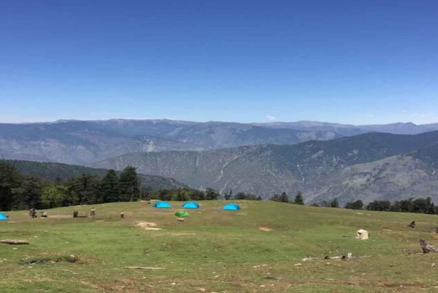
- 4 nights tented accommodation during the trek
- Trek equipment: Sleeping bags, Mattresses, Crampons, Gaiters, micro spikes, All kind of Utensils, Stools/chairs etc.
- Tents: Trekkers tent (twin/triple sharing), Kitchen & Dining tent, Toilet tent
- Entry Permit Fee, Guide Fee & Driver charges
- Standard vegetarian food for breakfast, lunch, snacks, and dinner during trek days
- 1 Mountaineering qualified & professional trek Leader
- Local Guide 1:6 ratio
- Chef & support staff
- Porters for carrying common equipment’s (like rations/tents/utensils/groceries)
- The facility of keeping extra luggage at our Pilonji base camp, when leaving for the
trek - Personal accident insurance
- Insurance, transportations, salary of guide & porter
- Basic First aid Kit
- All government, local taxes and service charges
- The Valley Rides Fee
- Personalized Dri-Fit T-Shirt
What is NOT included in the tour
- The cost to reach Rishikesh and back to your destination.
- Airport Pick up and Drop Off
- Personal trekking gear
- Tips for guide, chef, porter, etc (calculated per person)
- Excess baggage/porter charges
- Local sightseeing and entrance fee, camera fee, etc
- Mineral water or any type of soft drinks
- Hot water for shower, etc, during the trek
- Extra meals apart from inclusions
- Food during travel days
- Lunch and dinner while travelling from/to Rishikesh
- Any other expenses incurred apart from inclusions
- All personal, medical, evacuation and emergency expenses like extra day stay or
vehicle charges due to delays, landslides, evacuation.
You May Like
Dodital Darwa Pass Trek

Brahmatal Trek
Har Ki Dun Valley Trek

Subscribe newsletter $ get company news.
Ride the valley with us to explore the nature, waterfall and beauty. Valley rides Provide you a memorable experience to explore and feel the nature of Mountains.
Support
Contact Info
- The Conifer Inn Village Sour, Sankri , Teh. Mori District Uttarkashi, Uttarakhand
- © 2025 Ovatheme All Rights Reserved.


Reviews
There are no reviews yet.