
TREK DIFFICULTY
Moderate - Difficult
TREK DURATION
7 days
TREK DISTANCE
26.5 kms
AGE LIMIT
8 to 68 years
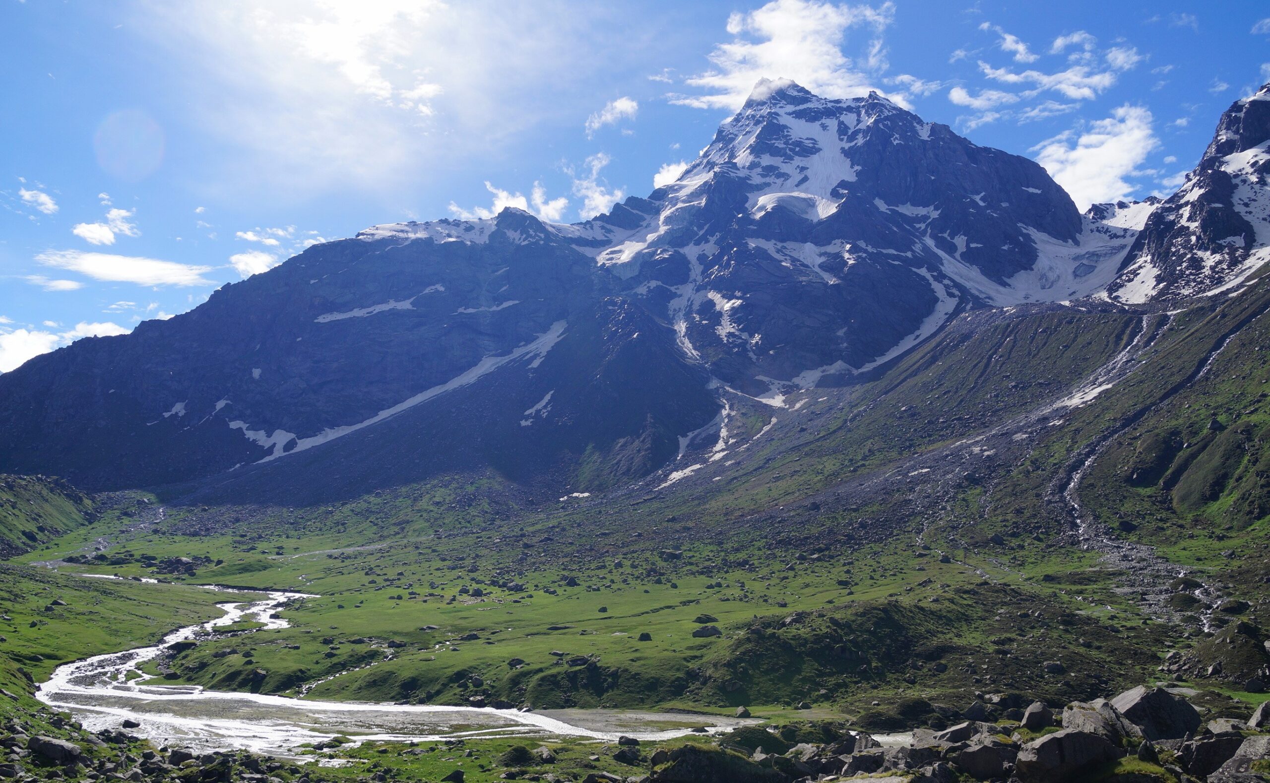
A Real Adventure Among Big Mountains
The Kedar Tal trek is for lovers of adventure. It is for those trekkers who have done a considerable number of Himalayan treks and now want to push themselves. It is a difficult trek, with a truly magical experience to give in return for all the effort.
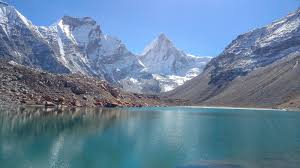
The trek climbs to the glacial Kedar Tal lake, sitting amid a cauldron of big mountains. Famous mountains of our country rise in front of you in this cauldron – Mt. Thalaysagar, Mt Bhrigupanth, Manda Parvat, Mt Jogin, and Mt Gangotri. You camp in the shadow of the mighty Mt Thalaysagar and Mt Bhrigupanth.
Very few treks bring you so close to such big mountains. And fewer still allow you to spend so much time in their proximity. The closest we can think of is Goechala, and that is a big statement to make.
The trail is also extremely remote. There is no human habitation at this altitude. And you find very few trekking groups on this trail. This solitude, when seen in comparison to a lot of other unfortunately crowded trails, is a blessing.
The trail, however, has a lot of challenges. You start the trek at around 11,000 ft and climb to over 15,500 ft. This altitude gain happens in 3-4 days. Climbing boulders, and navigating steep ascents and descents on tricky terrain becomes infinitely more challenging when you are also trying to catch your breath. This needs sufficient physical and mental preparation.
This preparation and hard trekking are rewarded amply on this trek – there are lovely bhoj Patra forests, vast high-altitude meadows and then there is the indescribable serenity of the Kedar Tal lake. You complete the trek having a very high feeling of accomplishment.
Before we start, here are some quick facts about the Kedar Tal trek:
The Kedar Tal Trek lies in the state of Uttarakhand. It begins and ends at the pilgrim town of Gangotri. It is approx. 26 km trek hiked over 4 days (7 days including a drive to and from the trek, and an acclimatization day) in the Himalayas.
It lies in the Greater Himalayas and is known for its brilliant big mountain views of peaks like Mt Thalaysagar, Mt Bhrigupanth, Manda Parvat, Mt Jogin and Mt Gangotri.
Kedar Tal – Trek Information
All trekkers should be well-informed before they go on a Himalayan trek.
Short Itinerary
DAY 1
Dehradun to Gangotri
Drive distance: 237 km
Drive Duration: 8 hours
Transport will be arranged from The Valley Rides assembly point at Gandhi Road, Dehradun at 6.30 am.
DAY 2
Acclimatization day around Gangotri (10,052 ft)
Go for hike around the Gangotri and back to campsite.
DAY 3
Trek from Gangotri (10,052 ft) to Bhoj Kharak (13,220 ft)
Trek distance: 6 km
Trek Duration: 5-6 hours
Moderate-difficult. Steep ascent all the way. The terrain is rocky in many parts.
DAY 4
Bhoj Kharak (13,220 ft) to Kedar Kharak (14,240 ft)
Trek distance: 2.5 km
Trek Duration: 3 hours
Moderate-difficult. 1 km of steep ascent followed by 3 km of moderate ascents and descents.
DAY 5
Kedar Kharak (14,240 ft) to Kedar Tal (15,500 ft) and back to Kedar Kharak (14,240 ft)
Trek distance: 5.40 km
Trek Duration: 8 hours
Difficult. Continuously ascending trail over a rocky terrain.
DAY 6
Kedar Kharak (14,240 ft) to Gangotri (10,052 ft)
Trek distance: 8.50 km
Trek Duration: 8 hours
Moderate. Continuously descending trail over a rocky terrain
DAY 7
Gangotri to Dehradun
Drive distance: 237 km
Drive Duration: 8 hours
IMPORTANT POINTS
- You will be staying in tents on all days of the trek.
- Trekkers must carry a copy of their photo ID for entry at forest check posts on the trek.
“Embark on a journey to serenity at Kedar Tal Trek: Where the mountains meet your soul.”
- You will be staying in tents on all days of the trek.
- Trekkers must carry a copy of their photo ID for entry at forest check posts on the trek.
DAY 1
Reach Gangotri
Drive Distance: 237 kms
Drive Duration: 8-9 hours drive.
Altitude: 10,052 ft (3,064 m)
Difficulty: Moderate ascent. Well-marked road followed by forest trails.
The trek starts at Gangotri the following morning. Gangotri is known as the source of the river Ganga (the actual source being Gaumukh), which is known as Bhagirathi here.
It is said that King Bhagirath prayed to Lord Shiva for the salvation of the souls of his 60,000 sons. Shiva obliged and requested Goddess Ganga to release her water, which purified the ashes of Bhagirath’s sons. This mythological story elevated the status of the river Ganga as a means to purify one’s soul.
DAY 2
Acclimatisation day in Gangotri
Use this day to get acclimatised to the altitude. Take a short trek up one of the trails around Gangotri and then return to base. You can spend the rest of the day exploring the area and taking in the pilgrim town’s sights.
DAY 3
Trek from Gangotri to Bhoj Kharak
Trek Distance: 6 km
Trek Duration: 5-6 hours
Altitude gain ⇗: 10,052 ft Trek to 13,220 ft
Difficult: Moderate-difficult. Steep ascent all the way. The terrain is rocky in many parts.
Take the steps going down to the right towards the Bhairav Ghati bridge across the Bhagirathi River. The trail to Bhoj Kharak begins as soon as you cross the river. You will also pass the ashrams of a few sages. The trail here has already begun to ascend.
After 200 meters, take a trail that climbs up sharply to the right, along the side of another ashram. This brings you to the forest trail to Bhoj Kharak. This frequently trekked route is the only path available to reach Bhoj Kharak. Here, the trail ascends steeply almost to Bhoj Kharak.
The trail is rocky in most parts. Being the first day of the trek, it is likely that you will struggle for your breath as lift yourself and your bag onto the rocks. Below you, you hear the Kedar Ganga river thundering past. The valley becomes narrower as you go deeper. There are short stretches of flat walks that allow you to catch your breath but the climb is relentless.
After an hour and a half of climbing, the conifer tree gives way to birch or bhoj Patra. The barks of these trees shed thin sheets that resemble paper. Due to the durability and texture of this bark, most of our ancient Indian texts were written on it.
After about four hours of trekking, the trail emerges out of the forest. Here, you get your first ‘spider wall’ or a narrow path on a near-vertical rock face. The trail has just enough space to keep a foot at a time. Focus on the next step and do not look down – you’ll be able to cross this path comfortably.
The trail climbs for another fifteen minutes before you reach the second spider wall. Cross this and you will reach the campsite within five minutes.
The Bhoj Kharak campsite consists of small strips of land lying to the left of the trail. There’s wild grass growing around. The valley here is quite narrow.
The closest water source is the stream flowing along the spider wall that you just crossed.
DAY 4
Bhoj Kharak to Kedar Kharak
Trek Duration: 4.2 km
Trek Duration: 3-4 hours
Altitude gain ⇗: 13,220 ft to 14,240 ft
Difficulty: Moderate-difficult. 1 km of steep ascent followed by 3 km of moderate ascents and descents.
The trek from Bhoj Kharak to Kedar Kharak is relatively simple compared to the previous day’s climb. Though there are a few grim patches, the terrain has uniform ascents and descents. The trek to Kedar Kharak, situated at 14,000 ft, is 4 km and takes about five hours.
The ascent is quite steep as soon as you set out of the campsite at Bhoj Kharak. After a 1 km trek through the Bhoj Patra forests, the trail leaves the tree line and enters meadows which are multi colours in autumn – an astounding setting for photography with the snow-covered peak Bhrigupanth in the backdrop.
The next 2 km feel like a relaxing stroll as there are fewer steep ascents. It is in this stretch that you may get a chance to encounter high altitude fauna like Bharal (blue sheep), Goral, Himalayan black bear and a variety of birds.
The climate gets chillier as you gain altitude. Do not be surprised if you notice a thin layer of frost over the stones in the streams. After passing about two more water points you reach Kedar Kharak.
The camp is set on a vast dry meadow with a few sparsely distributed boulders beside a wide stream. The stony path through which the stream climbs is the trail for the Day 4 Trek.
It is an exceptional sight to watch the sunset at Kedar Kharak. As the red ball of fire sinks behind the snow-clad Bhrigupanth the entire meadow looks orange and turns grey at dusk.
DAY 5
Kedar Kharak to Kedar Tal and return to Kedar Kharak
Trek Duration: 5.4 km
Trek Duration: 6 hours
Altitude gain ⇗: 14,240 ft (4,340 m) to 15,500 ft (4,720 m) and back to 14,240 ft (4,340 m)
Difficulty: Difficult. Continuously ascending trail over a rocky terrain.
On this day the excitement level is usually at its peak, with the eagerness to make it to the emerald lake taking over any exhaustion from the previous day’s treks.
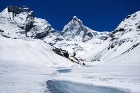
Start early as this stretch is the most laborious of all. At a height of 16,110 ft, the ‘Tal’ is a 5 km slog from Kedar Kharak through Rocky Mountains with absolutely no greenery around.
Despite the barrenness, the terrain can be quite exhilarating. With vigorous ascents and very few descents, it demands a great deal of energy and effort to be able to reach the destination on time, considering the unpredictable weather conditions, with the probability of snow and rain being quite high during this season.
If not careful, one can easily get turned around and it takes a while to realise that the route is off beam. For this reason, a lot of cairns (piles of stones) have been placed in route to the Tal to point in the right direction. Watch your step as there are plenty of loose rocks on the way. After about 5- 6 hours of trekking, and half a kilometre away from the lake, you can see the mighty Thalaysagar Peak across a rocky ridge.
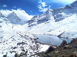
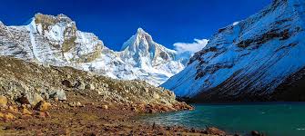
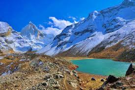
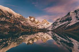
Once you cross this steep ridge, the descent to the lake begins. The temperature falls drastically at Kedar Tal. You can see the flawless reflection of the mighty old Thalaysagar peak on the Tal. Though the water is freezing, it is quite an experience to wet your fingertips in the emerald green lake.
Spend some time here and soak in the scenery before turning back to Kedar Kharak on the same route & retire for the day.
DAY 6
Kedar Kharak to Gangotri
Trek Distance: 9.2 km.
Trek Duration: 7-8 hours
Altitude loss ⇘: 14,240 ft to 10,052 ft
Difficulty: Moderate. Continuously descending trail over a rocky terrain
Start the descent to Gangotri right after breakfast. Trace the same path back and cherish the surroundings one last time. Since most of the trail is descending, it should take you lesser time to reach. Be mindful of loose rocks on the trail.
DAY 7
Return to Dehradun
Drive Distance: 236 km
Drive Duration: 8 hours
We will start at 8.00 am morning and will reach to Dehradun by 6.30 pm.
How Difficult Is Kedar Tal Trek
Moderate – Difficult
Suitable for Experienced Trekkers
We rate the Kedar Tal trek as “Moderate – difficult”.
The requirements for the trek are prior trek experience in the Himalayas (preferably above 14,000 ft) and good physical.
How Safe Is Kedar Tal Trek
Yes, it is safe to trek to Kedar Tal, but with adequate experience and technical know-how. This is important because the Kedar Tal trek is rated as Moderate – difficult, with challenging steep sections set at very high altitudes. So, it is not a trek to be taken lightly.
Safety Terrain Wise
The terrain of Kedar Tal Trek poses a challenge in terms of safety. Here are some of the sections on the trail where you need to take precautions:
- Spider wall on Day 1 of the trek (Gangotri to Bhoj Kharak): Right from the time you begin your trek, there is a steep ascent. Very few treks in the country start like this. You gain 2,000 ft almost instantaneously and the climb is nearly 45-50 degrees.
You trek through conifer and birch forests until you reach the spider wall section. The spider wall section is a steep rock face that is almost at an angle of 90 degrees. You traverse this section.
- Rockfall zone (Day 2 — Bhoj Karak to Kedar Kharak): On the second day’s trek, just as you start, within 400 m, there is a rockfall zone, the section also has scree, and there is a steep descent to add to the challenge. Further, soon after this, there is a river crossing as well.
- Summit Day — Kedar Kharak (14,240 ft) to Kedar Tal (15,500) and back to Kedar Kharak: Though this day is not as difficult as the previous two days, there are still challenges. The summit ascent is extremely steep. Followed by a flat rocky section, and then a 1 km ascent, again in a rocky section with boulders.
- The return from Kedar Kharak to Gangotri: This day’s trek is similar to your first day’s trek. You trace the route back. You approach the rockfall section at Kedar Kharak once again. Except that this time, you are descending. There is also an extremely slippery scree section, so be careful while descending.
You must use two trek poles here. This time, the snow on this section will be melting, so you must be extra careful with each step you take. You will have to negotiate the spider wall again. At The Valley Rides, our Trek Leader will help you with this.
Safety Weather Wise
On a high-altitude trek Kedar Tal, the weather does play a role in whether you continue a trek or not.
On the lower part of the trail, the weather is more or less stable and does not impact you’re moving ahead. But at higher altitudes, the weather is an unpredictable.
At altitudes above 15,000 ft, snowfall can happen anytime. A spell of rain on the lower slopes almost usually leads to light or heavy snow in the upper regions.
It can rain or snow at any time at such high altitudes. A rainfall or snowfall that lasts more than an hour can change your trek plans.
On the Kedar Tal trek, snowfall is a distinct possibility, especially in the summers.
The Valley Rides team along with the Trek Leader takes a call on when to proceed with the trek and when to turn back. A team may have to turn around from the highest camp if the weather turns worse.
At The Valley Rides, we have kept the safety of our trekkers as well as staff as an utmost priority while planning the trek route.
Kedar Tal in Summer (mid-May to end-June)
Day Temperature: The day temperatures are pleasant at an average of 15 – 20 °C | Night Temperature: Nights can get cold, with the mercury dropping close to zero degrees. When it rains or snows, expect the daytime temperature to drop below 10 °C.
Rain/Snow in summer: The weather is quite unpredictable and volatile during the summers. The weather changes unannounced and it could abruptly start raining or even snowing.
Number of warm layers recommended in Summer: 3-4 warm layers
Kedar Tal in Autumn (mid-September to mid-October)
Day Temperature: Days can be quite warm with temperatures going as high as 20 °C | Night Temperature: The evenings at the campsite can get cold. Don’t be surprised if the temperatures fall below zero at night. Expect the overall temperatures to fall by 3-5 °C every couple of weeks as the season progresses.
From October, any precipitation comes down as snowfall in the higher camps. When it snows, expect 3-4 inches of snow. The initial bouts of snow tend to melt away in the sun. By the end of October, the cold increases manifold, water sources freeze and trekking becomes untenable.
Number of warm layers recommended in Summer: 4-5 warm layers
What to Pack on the Trek
Things you must take on the trek
MANDATORY DOCUMENTS
These are documents required for legal purposes by The Valley Rides and the forest department. Without any of these, you will not be allowed to trek.
- Original and photocopy of government photo identity card. Anything such as a driver’s license, Aadhar Card, or passport will do. This is required by the forest department for your identification.
- Disclaimer certificate: There are two sections in this. The first part is a personal medical record. The second part is a legal requirement. Download the PDF, read carefully, fill in and sign it. This must be handed over to your Trek Leader during registration at the base camp.
- Medical certificate: The medical certificate needs to be filled out by an MBBS doctor, without which the forest department will not issue permissions for your trek. It is also a requirement by The Valley Rides.
Here is a list of everything you need for your trek.
Shoes and backpack
- Trekking shoes with ankle support)
- Backpack with rain cover
- Warm Layers and Clothes
- Warm layers –
1. 3 layers if you’re trekking in spring, summer and monsoon (1 woollen sweater, 1
fleece, 1 padded jacket)
2. 4 layers if you’re trekking in autumn (1 woollen sweater, 2 fleece, 1 padded jacket)
3. 5 layers if you’re trekking in winter (1 pair of thermals, 1 woollen sweater, 2 fleece, 1 padded jacket) - 3 Collared T-shirts (Wear one, carry two)
- 2 quick-dry trek pants (Wear one, carry one)
Accessories
- Sunglasses
- Sun cap with flaps
- Waterproof gloves
- Balaclava
- Socks (2 pairs of Dry fit + 1 pair of Woollen)
- Headlamp
- Trekking pole
- Rain jacket + pants/poncho
Toiletries
- Sunscreen
- Moisturiser
- Light towel
- Lip balm or Vaseline
- Toilet paper
- Toothbrush
- Toothpaste
- Reusable plastic covers (for used clothes)
- Water bottles
PERSONAL MEDICAL KIT
Carry these medicines with you, easily accessible at all times.
- Diamox: 1 Strip
- Dolo 650: 5 tablets
- Avomine: 4 tablets
- Combiflam: 5 tablets
- Digene: 4 tablets
- ORS: 6 packs
- Knee Brace: optional
Inclusions & Exclusions
What is included in the tour
⦁ Transportation to & fro from Dehradun to Gangotri Base Camp.
⦁ 3 nights camp/hotel at Gangotri.
⦁ 3 nights tented accommodation during the trek
⦁ Trek equipment: Sleeping bags, Mattresses, Crampons, Gaiters, micro spikes, All kind of Utensils, Stools/chairs etc.
⦁ Tents: Trekkers tent (twin/triple sharing), Kitchen & Dining tent, Toilet tent
⦁ Entry Permit Fee, Guide Fee & Driver charges
⦁ Standard vegetarian food for breakfast, lunch, snacks, and dinner during trek days
⦁ 1 Mountaineering qualified & professional trek Leader
⦁ Local Guide 1:6 ratio
⦁ Chef & support staff
⦁ Porters for carrying common equipment’s (like rations/tents/utensils/groceries)
⦁ The facility of keeping extra luggage at our Gangotri base camp, when leaving for the trek
⦁ Personal accident insurance
⦁ Insurance, transportations, salary of guide & porter
⦁ Basic First aid Kit
⦁ All government, local taxes and service charges
⦁ The Valley Rides Fee
⦁ Personalized Dri-Fit T-Shirt
What is NOT included in the tour
⦁ The cost to reach Dehradun and back to your destination.
⦁ Airport Pick up and Drop Off
⦁ Personal trekking gear
⦁ Tips for guide, chef, porter, etc (calculated per person)
⦁ Excess baggage/porter charges
⦁ Local sightseeing and entrance fee, camera fee, etc
⦁ Mineral water or any type of soft drinks
⦁ Hot water for shower, etc, during the trek
⦁ Extra meals apart from inclusions
⦁ Food during travel days
⦁ Lunch and dinner while travelling from/to Dehradun
⦁ Any other expenses incurred apart from inclusions
⦁ All personal, medical, evacuation and emergency expenses like extra day stay or vehicle charges due to delays, landslides, evacuation.
You May Like
Do Dham Yatra

Bali Pass Trek
Har Ki Dun Valley Trek
Valley of Flowers Trek

Subscribe newsletter $ get company news.
Ride the valley with us to explore the nature, waterfall and beauty. Valley rides Provide you a memorable experience to explore and feel the nature of Mountains.
Support
Contact Info
- The Conifer Inn Village Sour, Sankri , Teh. Mori District Uttarkashi, Uttarakhand
- © 2025 Ovatheme All Rights Reserved.


Reviews
There are no reviews yet.